 |
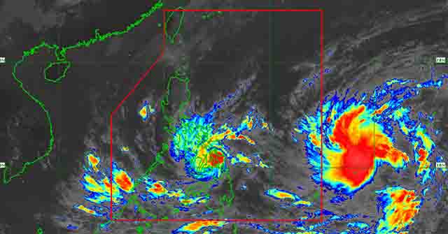
| According to PAGASA, Tropical Storm Agaton intensified and remained stationary Sunday morning just off the coast of Eastern Visayas. Photo: PAGASA |
TACLOBAN CITY – Tropical Storm Agaton remained stationary Sunday morning just off the coast of Eastern Visayas, according to the state weather bureau PAGASA.
The center of Tropical Storm "AGATON" was estimated using all available data, including those from the Guiuan Doppler Weather Radar over the Guiuan, Eastern Samar coast.
According to PAGASA's 11:00 a.m. Tropical Cyclone Bulletin, the storm has maximum sustained winds of 75 km/h near the center, gustiness of up to 105 km/h, and a central pressure of 996 hPa.
The tropical storm is dumping heavy rains on areas affected by Tropical Cyclone Wind Signal No. 1 and Signal No. 2 and neighboring provinces.
Signal No. 2 is raised over the following areas:
Visayas: The southern portion of Eastern Samar (Guiuan, Mercedes, Salcedo, Quinapondan, Giporlos, Balangiga, Lawaan, General Macarthur, Hernani, Llorente, Balangkayan, Maydolong, Borongan City), the southern portion of Samar (Marabut, Basey, Calbiga, Pinabacdao, Villareal, Santa Rita), and the northeastern portion of Leyte (Babatngon, Tacloban City, Palo, Tanauan, Tolosa).
Mindanao: The northern portion of Dinagat Islands (Loreto, Tubajon).
Meanwhile, Signal No. 1 is raised in the following areas:
Visayas: The rest of Eastern Samar, the rest of Samar, Northern Samar, Biliran, the rest of Leyte, Southern Leyte, and the northeastern portion of Cebu (Daanbantayan, Medellin, Bogo City, Tabogon, Borbon, San Remigio) including Camotes Islands.
Mindanao: Surigao del Norte and the rest of Dinagat Islands
Residents in flood- and landslide-prone areas are advised to take appropriate precautions.
Due to the weak steering environment, "AGATON" is expected to move erratically or remain almost stationary over the southern portion of Samar Island and its coastal waters today through early Tuesday. The forecast track may shift westward due to the expected erratic movement.
As a result, it may move over coastal waters or make another landfall over Leyte.
TS Agaton is expected to remain a tropical storm for most of the forecast period. However, the possibility of downgrading to a tropical depression is not ruled out due to the potential impact of land interaction on the tropical storm.
PAGASA said that the tropical storm is expected to degenerate into a remnant low by late Tuesday or early Wednesday as "MALAKAS" begins to assimilate its circulation. —Tacloban News Update (Source: PAGASA)
